French sector
The French Sector
Of all the facets of the Gallipoli campaign, it might be argued that the actions and contribution of the French forces has received less attention in terms of research and commentary than others. Morto Bay is busy during the high season because of the large numbers visiting the dominating Turkish memorial at Eski Hissarlik Point, but less than a kilometre away lies an area which may well be a contender for the least-frequented of the accessible parts of the peninsula.
The French held this area, on the extreme right of the line at Helles, and fighting in the vicinity of the Kereves Dere, one of the gullies which run down from Achi Baba at the extreme eastern edge of the front line, was particularly intense.
A specific interest of mine is battlefield topography and the non-invasive search for extant archaeology.
A few years back I had the opportunity to devote two days to walking the French sector.
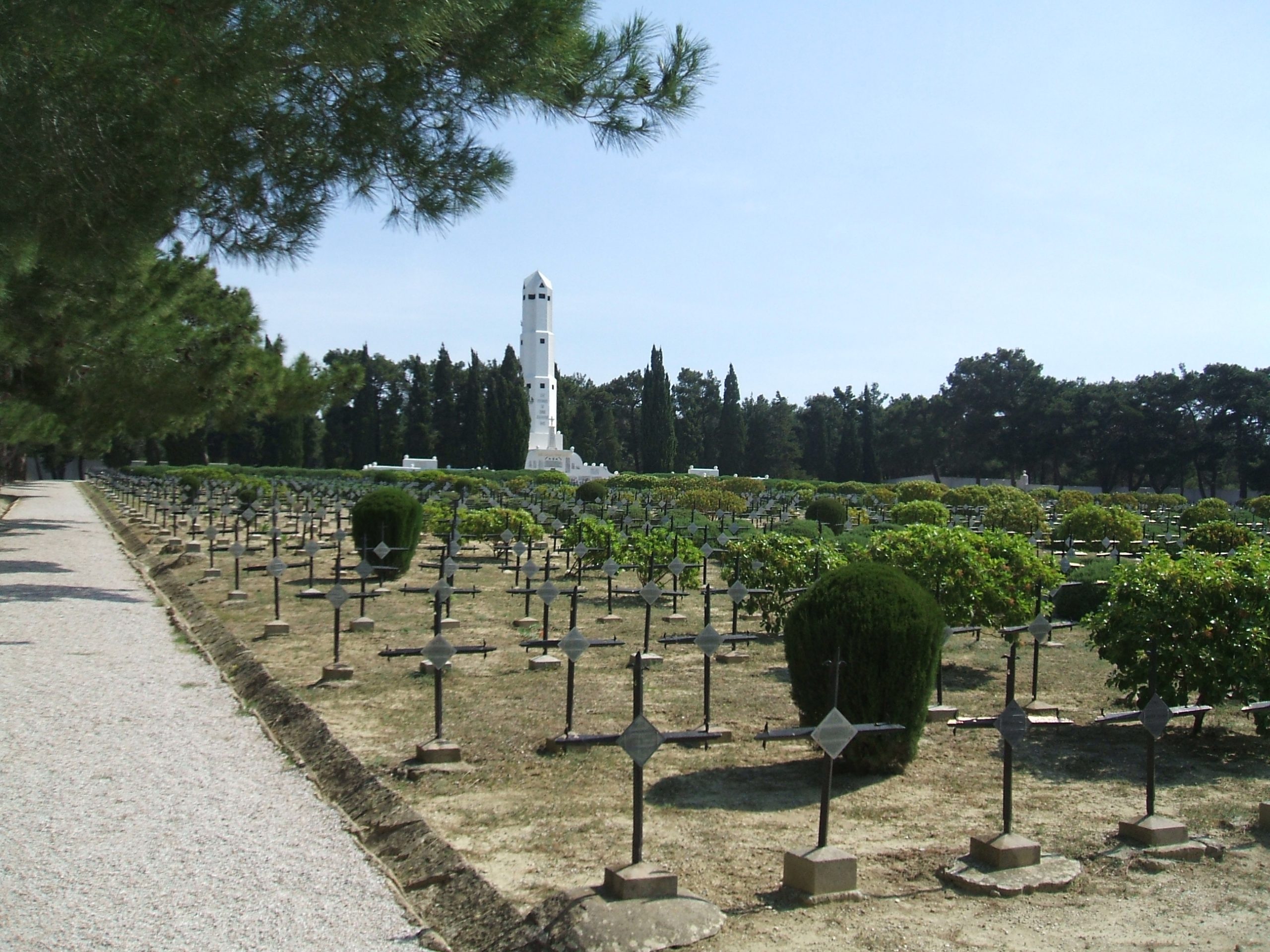
The imposing French cemetery, with its stark steel crosses, is a quiet counter-point to the bustling Turkish site nearby. Those who come here almost always leave again by the main entrance to the south. Just a short distance to the north however, the cemetery walls give way to thick woodland, and within these trees lies a wealth of evidence of the French presence which can still be found.
Two major communications trenches began and ended in this vicinity, the Avenue de Constantinople running north eastward up to the front line, and parallel to it, the Avenue de Paris returning to the reserve areas, running broadly north north east to south south west. To their left is the route of the light railway, about which more later.
Prior to travelling to the peninsula, I had spent some time overlaying contemporary trench maps onto Google Earth images of the area, and I had a series of GPS waypoints programmed into my Garmin Etrex. In fact, in the case of the communications trenches, this was hardly necessary, since their lines are still quite evident in the satellite images and simple compass bearings can be used for locating them. After ten minutes walking under the tree canopy, I came across their remains, still more than a metre deep, separated by some 6 metres. A number of smaller unnamed trenches intersect them. I was able to follow the avenues for some distance, until they ran out of the woodland to the east and were lost in the ploughed land beyond.
The French constructed a light railway in this sector to service their forward positions, particularly the Redoubt Bouchet. It began at a location shown on 1915 maps as ‘Snipers Wood’. Google Earth overlays revealed that the track bed ran close to a distinctive looking area of woodland which has survived the decades since 1915 almost unchanged, making its position relatively easy to locate on the ground. Intriguingly, a clear line or path crossing a field to the south of this woodland area can be seen on Google Earth, precisely where the 1915 maps show the railway track running.
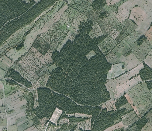
Above, a Google Earth screen shot of the French sector. Note the small rectangular field toward the top of the triangle-shaped woodland north of the French cemetery. A distinct white line can be seen running from left to right diagonally through it.
On one recent visit I took the internal flight from Istanbul airport to Cannakale, and, as a quite unexpected bonus, the aircraft crossed the peninsula on its landing approach. I had a clear view of the French sector from my window seat, and whilst I was able to identify the field in question, I was a little disappointed to see that it has been ploughed, and that there was now no sign of the mysterious line. It was quickly obvious that the Google Earth imagery was taken at a time when the field was in crop. As archaeologists and field walkers will know, features beneath the surface are often revealed in dry weather by the uneven crop growth above.
It took less than 5 minutes to walk from the Avenue de Paris to the clearing. At first sight, there was nothing unusual there. The field was indeed ploughed, but it had not been planted, so I ventured a short way onto the tilled earth. From this vantage, I was then able to see the line of a narrow depression, a metre wide, which ran across the field diagonally, precisely where the railway would have been. This feature is quite different to the remains of a trench, and it runs as straight as a die. Beyond the field to the west and east, it disappeared into trees, and time prevented further exploration. I am fairly convinced however that this is the old railway bed.
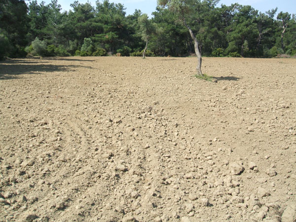
The field shown on the Google Earth Map is photographed above. It would appear that the line is created by uneven crop growth, which is very common where an archaeological feature lies under the soil. when I visited in May 2009, the field was ploughed, and a distinct straight depression could be discerned, beginning at bottom right on the photo and running diagonally. It is too shallow and probably too straight to be the remains of a trench.
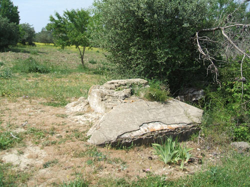
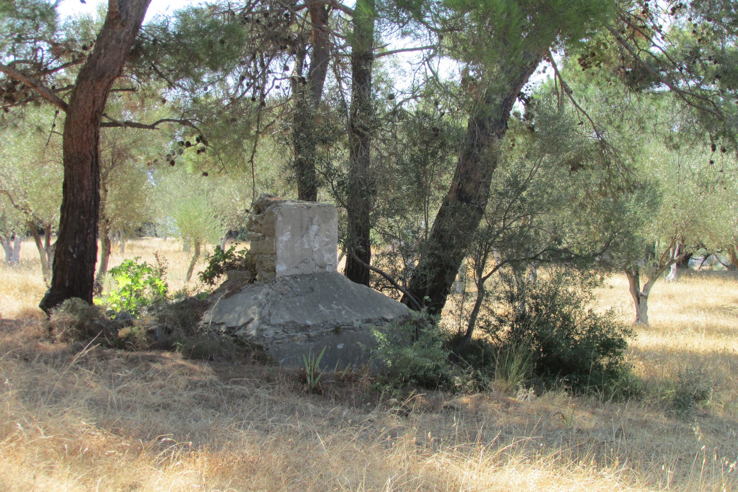
The woods in this area are replete with the remains of trenches and dug-outs, and the tree growth and the lack of visitors has served to maintain a very high level of preservation. To the west of the light railway area are the overgrown remains of Zimmerman’s Farm. On the eastern and uphill side of the farm house ruins a rather odd structure can be found, photo below. It is generally pyramid-shaped, and has no openings or windows. In fact, this is the crumbling remains of another French memorial, almost identical in design to a second in a field about 500 metres away to the south west. The plaques which were once mounted on these independent memorials are now on the back wall of the main French cemetery. The Zimmerman Farm monument can be linked to the plaque there which carries the inscription ‘To the heros of the Zimmermann Farm and Maltepe Ravine battles – April 1915 – 4th Mixte Colonial / 175th Infantry Regiment’.
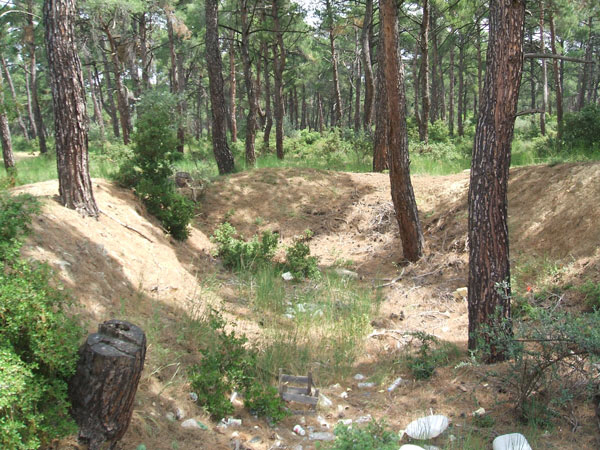
A few hundred metres north east of Zimmerman’s Farm lie two large embanked pits, picture below, some 5 metres wide and ten metres long. They are well hidden and generally unknown to the casual visitor. Sadly, they are full of modern rubbish, and some commentators have even suggested that it was for this purpose that they were dug. This cannot be the case however. A quick inspection reveals trees of a respectable age growing both in the floor of the pits and in the side walls, indicating that they took root later than the digging of the pits themselves. The workings stand side by side, with the southern ends open. This is significant because their embanked opposite ends face towards the front line. They strongly suggest a storage or bunkering function, and it has been proposed that they were dug specifically for the Rolls Royce Armoured cars which were operated by the Royal Naval Division for a brief time at Gallipoli, Zimmerman’s Farm standing on the dividing line between the RND and French areas of responsibility. Contemporary photos of the vehicles in their pits appear to be from the known and documented parking area near Gully Beach however, and thus far, I have been unable to find a definite connection with the pits at Zimmerman’s Farm. It is also possible that the pits were for field guns, but in that case it is more likely that evidence of these heavy pieces of ordnance would still be there, as they are in other locations at Helles. A final speculation is that they were dug at the evacuation as troop shelters as men mustered for embarkation at V Beach.
In the woods to the north west of the French cemetery are two more memorials, one in a field, pictures below, approximate What3words location ///vigilantly.breeding.litter, and the other just inside the treeline to east, seldom visited. Between the two memorials, at the edge of the woods, there are blocks of dressed stone with some remaining marble facings, perhaps from a third construction, now destroyed?
As mentioned above, all the woodland memorials have had their plaques and inscriptions removed andplaced on the northern wall of the nearby French cemetery. This took place when the main French cemetery was established in 1923 after the Treaty of Lausanne.
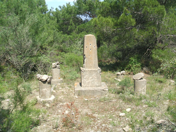
The better-known and most easily found French memorial east of Zimmerman’s Farm. This is mentioned in some Gallipoli guide books. The structure is sadly neglected, although someone has taken the trouble to gather up and remount the broken parts of the outlying pillars.
I would be delighted to hear from anyone with further knowledge or information about these memorials.