Visit
Visiting the Gallipoli Peninsula and walking Gully Ravine
This is a long continuous page. Use the sub-
- Travel to the Gallipoli Peninsula
- Accommodation
- Getting around the peninsula
- Preparation for the gully walk
- Resources and artifacts
- Into the gully
- Turkish language
The Gully is located on the western side of the Gallipoli peninsula, in the Helles sector. The closest centres of population are Alcitepe, which is less than a kilometre from the northern end of the Gully, or Sedd El Bahr, about 6 kilometres to the south west, the location of V Beach. These are both relatively small villages.
Do please note that whilst I am an enthusiastic and relativeley experience traveller to Gallipoli, what follows is based on my personal experience and should not be construed in any way as specific recommendations or professional advice concerning travel or accommodation. For specialised information on travel to Turkey, I recommend Tom Brosnahan’s Turkey Travel Planner site.
Travel to the Gallipoli Peninsula:
Many visitors travelling to Gallipoli will arrive in Turkey via Istanbul’s newish Grand Airport (known as ‘IGA’). This is some 250 km from the Gallipoli peninsula, but it is still slightly nearer and has better overall travel facilities than the other two choices of airport, namely Istanbul Sabiha Gokcen, and Izmir, the latter of which is a long way to the south west. British Airways and Turkish Airlines run direct daily scheduled flights from the UK to Istanbul and Izmir. There are other airlines offering flights but these sometimes involve a change of aircraft at a European stop-
From Istanbul there are currently there are four ways of getting to Gallipoli, namely internal air flights, coach, taxi or hire car.
Air: In the relatively recent past there were smaller airlines running internal flights to Canakkale from Istanbul, taking just 50 minutes, but at present these appear to be unavailable. Turkish Air does fly there, but via Ankara, taking some 8 hours, which is twice as long as travelling by coach, and is hugely expensive.
Bus: Turkey has a superb long-
At the Otogar, Truva and Metro are the companies that offer the most frequent services to Gallipoli. Kamel Koc, the biggest coach company in Turkey, also run services, but timings are not as frequent.
The journey takes about 5 hours, with a few rest stops. The service is good, with nibbles, free drinks and freshen-
Taxi: Taxis from the airports can be booked in advance, with a journey time of about 5 hours (depending on the driver). As one would expect, costs are high, around £250 – £300 for a single journey (also depending on the driver!). Bear in mind that this is roughly the UK equivalent of taking a taxi from London to Exeter.
Car hire: Cars are easy to hire in Turkey. You will need to present an internationally accepted driving licence, with costs at around £30 – £40 a day for a small 2 door car. Air conditioning is relatively essential.
It is generally recognised that Turkish driving is ‘passionate’. You also need to factor in the huge and seemingly permanent congestion in and around Istanbul. Once on the peninsula, things are very different, with little traffic (except around 25 April) and quiet if sometimes rather rough roads. I have hired cars and motor scooters locally, an arrangement which works well. On the roads, be prepared for infrequent use of indicators, ‘undertaking’, and a disregard for pedestrian crossings. Take it easy. Turkish drivers are very laid back and it pays to adopt the same attitude.
If you can spare the extra days, an interesting choice is to fly into Izmir and hire a car to drive up the western Turkish coast to Gallipoli. It can be done in a day if needed. Along the way, for history enthusiasts, it is possible to make a worthwhile detour to Troy. Assos and biblical Troas are also en-route.
The new 1915 Canakkale suspension bridge, which is the longest of its type in the world, is now open. Situated near Gelibolu on the north side of the straits and Lapseki on the south, the bridge makes the crossing of the Dardanelles quicker and easier than the ferries which ran before. The bridge was opened on 18 March 2022, precisely 107 years after the repulse of the allied fleet by the forts and guns in the Eceabat and Canakkale areas further to the west.
My own choice would be to travel from Istanbul by coach and then hire a car locally. There are several car hire companies in Canakkale.
A last comment. If you aim to get to the peninsula by coach, it is recommended that you fly in to IGA or Izmir airports, not Sabiha Gokcen. Arriving at this latter airport will mean getting a local bus, taxi or train into the centre of Istanbul or over to the Esenler Otogar for ongoing travel, all of which adds an unnecessary layer of organisation and a few extra hours of travelling.
Timing your travel
April 25th is the anniversary date of the landings at Gallipoli, and every year thousands of Australian and New Zealand visitors arrive for the Dawn Service at Anzac Cove. If you are travelling specifically for this, then well and good, but if you do not need to be at Gallipoli in this period then it is best avoided, because accommodation will be scarce and travel around the peninsula will be unusually busy and restricted.
May is an excellent time to travel. The flowers will be in bloom and the weather will probably not yet be fiercely hot. Alternative, September is recommended. The hottest weather will be over, but bear in mind that the land may be parched and dry.
Do check the dates for Ramazan (‘Ramadan’ in other Islamic cultures), in the year you intend to visit. This is not to say that those who are not of the faith of Islam should not travel to Gallipoli in the Muslim holy month, but bear in mind that finding somewhere to eat during daylight hours may be more difficult and you could well be woken before sun-up by enthusiastic drummers, who loudly call the faithful to rise for their ‘sahur’, the first meal of the day, eaten before observing the daily Ramazan fast. There could also be some local transport restrictions. On the flip side, evenings after sunset will be full of life and celebration. See Tom Brosnahan’s comments on Ramazan below.
Ramazan (Ramadan) in Turkey (turkeytravelplanner.com)
Although it is gaining in popularity, the Gallipoli peninsula is still a bit ‘off the beaten track’ in Turkey, and hotels and accommodation can reflect this. In any case, what passes for 3 star in Turkey will not be anything like the same standard as London or Manchester. An easy-
The basic choice is between hotels and pansiyons, (B & Bs). When choosing accommodation, you also need to make decisions about access to the battlefield areas.
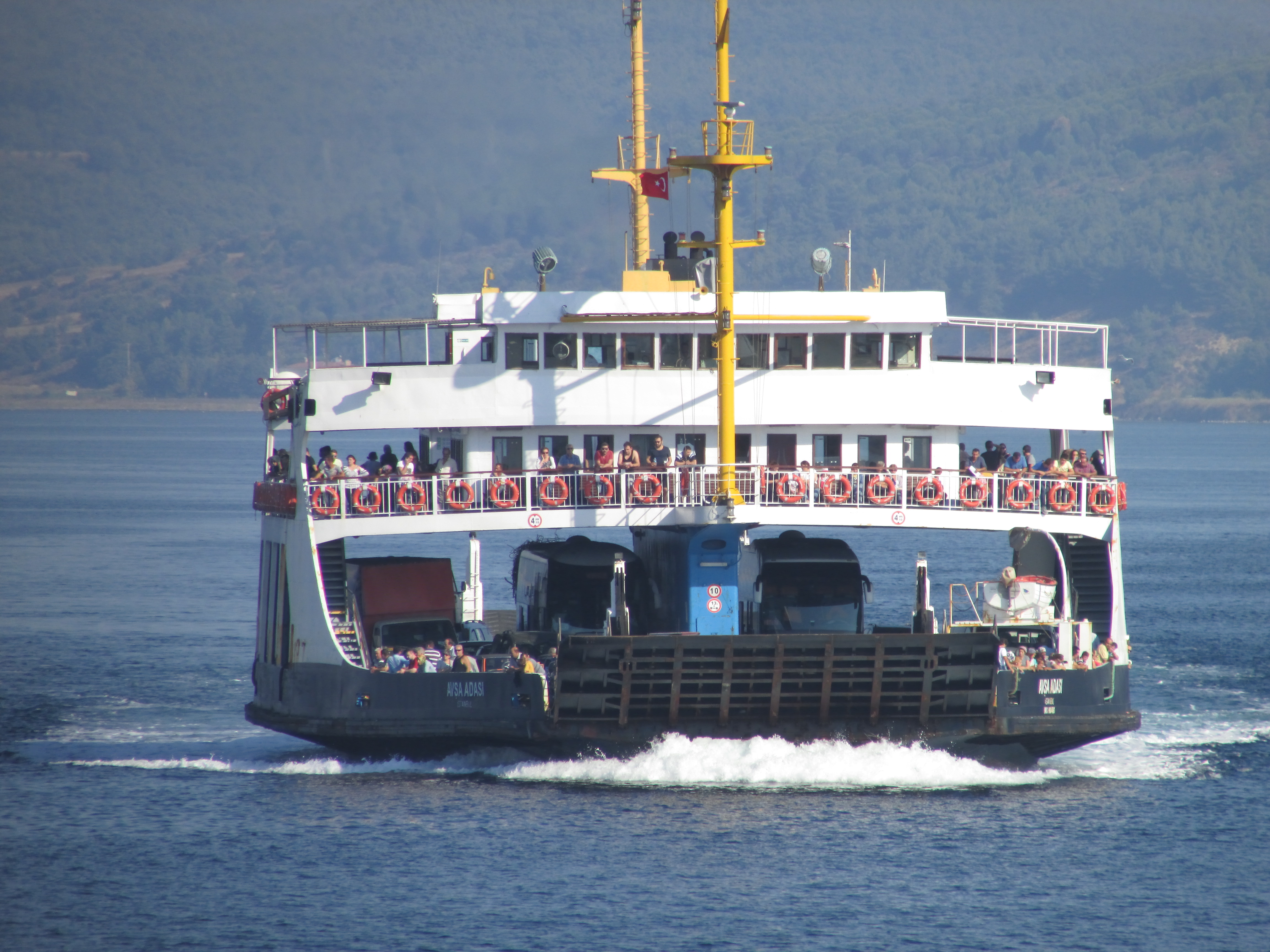
Eceabat and Canakkale are about 30 kilometres to the north east from Cape Helles and around 12 kilometres south east from the Anzac areas. Canakkale is the largest town locally, but bear in mind that if you stay there, you will need to cross the straits and back via the ferry every time you visit the battlefields, thereby adding at least two hours and some extra costs to your daily programme
Eceabat, on the northern ’battlefield’ side of the straits, is smaller, but does have some hotels and a few restaurants. My preference is to use Eceabat as a base. It is then easy (and quite pleasant) to cross the straits as a ferry foot passenger in the evening for the wider selection of places to eat in Canakkale. More about the ferries below.
As mentioned above, the following are a few pointers to accommodation that I have personal experience of. Please note however that I am not a travel writer/agent, and what follows is not a formal recommendation:
Helles Panorama, Sedd El Bahr: This is the home of Errol Baycan and his wife, and their large house stands on hill 141, just a few metres from Doughty-
The Grand Eceabat hotel is situated literally adjacent to the ferry berth. The hotel offers good if rather basic accommodation, and it has a wonderful rooftop restaurant/bar area with superb views across the Dardanelles. The hostel opposite is more backpacker style with dormitory accommodation and suitably lower prices.
Villa Bagci, just west of the town centre, is superb. A small family-
On the southern side of the straits, in Canakkale, there are many hotels, and the benefit here is that there are far more facilities, particularly for eating, car hire, shopping and supplies etc. As stated elsewhere, the drawback is that if you are in the area specifically to visit the battlefields, you will have to cross the straits by ferry every day, adding two or more hours and extra travel costs to your daily programme.
There are dolmuses , (pronounced ‘Dolmush), that is, shared buses, running between Eceabat and Cape Helles, and also to Anzac. They seem to run about every 30 minutes to an hour, but there is no obvious timetable and drivers will not necessarily speak English. This is a very cheap way of getting around if you have time to spare and can master the system. They will stop anywhere on the road if you indicate with a wave. (Conversely, if you are on your mobile do not gesticulate, or you may find a queue of dolmuses stopping to pick you up!). Costs for journeys are very modest.
The main ferry runs at least hourly between Canakkale on the south side of the Dardanelles and Eceabat on the north side. The service reduces in frequency in the small hours of the night. As mentioned elsewhere, the battle sites are on the north side, but Canakkale has most of the facilities. Two people in a car can cross for about £12. There is also a smaller and slightly cheaper ferry which runs from Canakkale to Kilitbahir, to the west of Eceabat.
There are plenty of taxis in Canakkale and Eceabat. If you are staying in Canakkale, note that there is no point in hailing a taxi there to take you over the straits. Instead, walk onto the ferry, pay for the ‘on foot’ crossing and then get a taxi on the other side at Eceabat. Don’t necessarily expect taxi prices to be significantly lower than the UK. Try to negotiate a price first, or at least check that there is a meter running.
Car hire: Barring 25th April and the surrounding days, when thousands of mainly young Australian and New Zealand pilgrims arrive for the Anzac Day remembrance events, car hire is a good choice, especially if there are between 2 and 4 of you. Once out of the towns, traffic will not be a problem. Parking is free at the various memorials, although apart from the main locations such as the Helles Memorial, Nuri Yamut and at Chunuk Bair, which have proper car parks, it is often a matter of finding a verge to pull up on.
Note carefully that the only petrol stations in the area once you are on the north side of the straits are in Eceabat, both of them on the bypass road that loops around the north of the town. If you are heading off to Cape Helles or to Suvla for the day, make sure you have plenty of fuel. This is especially important in hot weather, when the air condition system will reduce your MPG. Consider buying an extra fuel container for emergencies.
Walking: A round walk from Eceabat to Helles is about 60 km (40 miles) so very few will be able, or want to do this. However, once you are in the vicinity, especially if you are visiting Gully Ravine and the spurs, there is really no choice but to walk locally. See below for sensible precautions.
Preparations for walking Gully Ravine:
Most of this is common sense:
Take lots of water.
Check the weather. Any rain will make the gully stream bed difficult to get through. between late April –
Consider carefully the possibility of walking with someone else or as part of a group. Once in the gully you are completely cut off from the outside world. Your mobile is unlikely to work, and the loudest shout will go unheeded unless there happens to be a shepherd (who understands English!) nearby.
Tell someone where you are going, and when you expect to be back.
Take lots of water, especially in hot weather. (Did I mention that earlier?). Food is also likely to be necessary since the complete walk can take up to 4 hours, depending on how many stops and diversions you make.
Take maps and guides etc. The best book on the area is undoubtedly Stephen Chambers’, ‘Gully Ravine’, See below under ‘resources’.
Take a basic first aid kit and any medication needed on a regular basis.
A number of guide books mention dogs or packs of dogs in the Pink Farm area and around Gully Beach. There are some strays, but most dogs are working with shepherds to marshall sheep and goats. As a precaution, take appeasement in the form of dog biscuits. I have been barked at by sheep dogs, who appear simply to want to let you know who is boss, but I have never really felt threatened. If working dogs approach you, the best idea is to stand quite still and don’t make eye contact until they has passed by with their herd. Stray dogs by contrast are usually quite timid, and permanently hungry!
A good pair of walking boots is more or less essential and open-toed shoes are definitely to be avoided. The gully path is soft sand for much of its course but this is completely untamed land, and holes, divots and loose rocks are commonplace. Sunglasses and a sun hat may also be required. I would not recommend walking in shorts or skirts. The grass can be prickly and razor-
Depending on the season, be prepared to climb over or crawl under fallen trees.
Although the possibility is fairly remote, you may just come across live rounds, hand bombs or even shells. These are approached and touched, literally, at one’s peril. Stay clear.
A map of Gully Ravine will be very useful, although one argument is that once in the gully, you just keep going to its other end! A book which describes the background and actions in this this area would also be useful and the two requirements can be perfectly combined by acquiring a copy of Stephen Chamber’s excellent book, suitably named ‘Gully Ravine’, Battlefield Europe series, ISBN 0850529239.

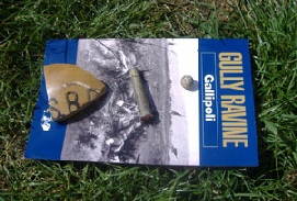 The book is pictured left with a few artifacts found on the surface around the area of the Eastern Birdcage on one of my recent walks through the ravine, namely, a piece of ‘SRD’ rum jar, a British .303 cartridge and a shrapnel ball. They were left where they were found after the photo was taken.
This is a good place for the mini-
Although admittedly unlikely, it is also just possible that some ordnance may still be live. Leave it be!
Sermon ended. Amen.
To walk the entire length of Gully Ravine, or at least, the most relevant parts, it will probably be necessary to make some transport arrangements. The notes that follow assume a walk from the southern end at Gully Beach, to the northern part, at Nuri Yamut (Fusiliers’ Bluff). If you are walking southwards down the ravine then a reversal of the suggestions below will work fine. You may want to arrange for a taxi to pick you up at your eventually finishing point. Serious hikers can of course walk the gully in both directions to arrive back at their starting point, perhaps by coming back down via Gully Spur or Fir Tree Spur.
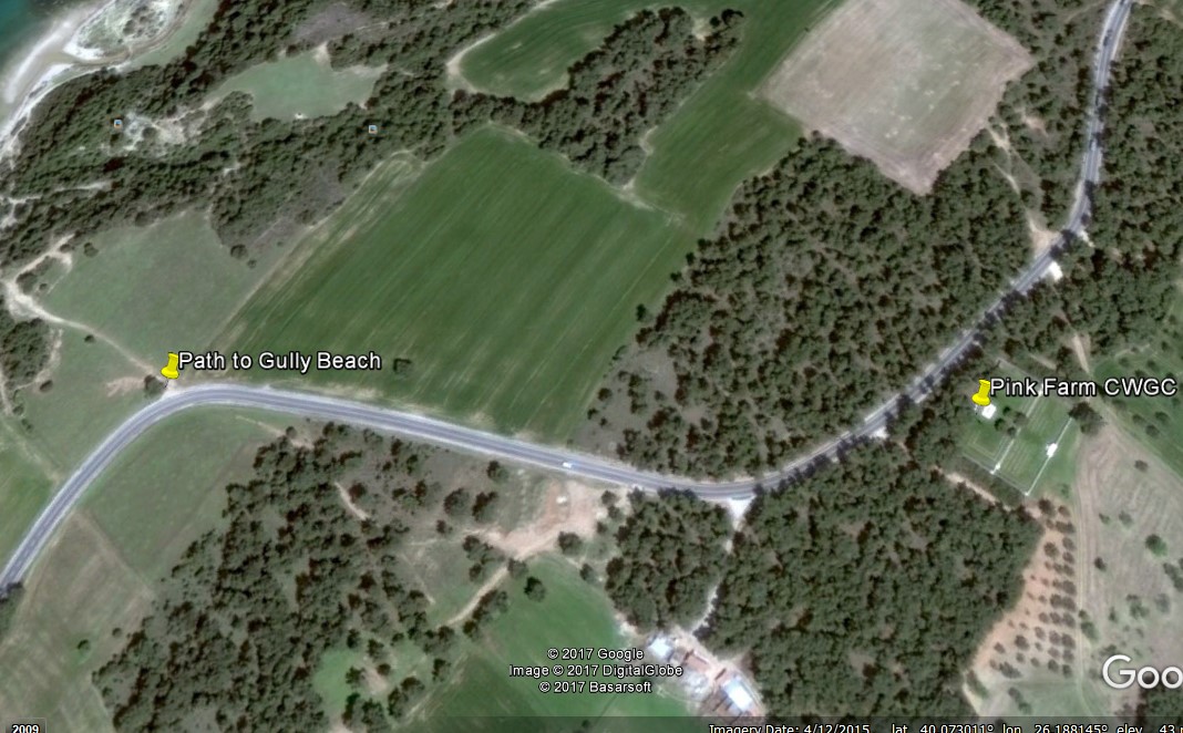
Whatever transport you use, you need to arrive at Pink Farm Cemetery or just to the south west of this, at a distinctive bend in the road.
Pink Farm CWGC is the closest cemetery to the Gully and most of the 602 burials and commemorations here are soldiers who fell in the local area. The farm itself was the base for a mining company later in the campaign, as described in Jo Murray’s first hand account published as ‘Gallipoli as I saw it’. The area derives its name from the reddish soil.
If arriving by car, drive along the track in to the cemetery’s east side, and park in the shade. ///suppliers.assembly.charismatic
Walk south west along the road from Pink Farm cemetery. The road takes a sweeping ‘S’ turn, and from the bend, you will be able to see the Helles Memorial with Seddulbahir on its left. To the extreme left, you may also glimpse the distinctive Turkish Memorial at Morto Bay.
To your right, the land is flat and runs across the fields to the cliff top above the sea. Close to a cluster of trees on the bend you will see a track that gradually descends, becoming sunken, to the north west. This is the path down to Gully Beach. See the Google Earth screenshot following. The precise coordinates for the beginning of the path to Gully Beach from the road are 40.072917°, 26.185434°. ///hyper.tokens.regulates
Gully Beach and its headland can just be seen in the extreme upper left of the image.
As the path descends, you can either take the (relatively) easier route that curves right and then left down the hill, or the more extreme route straight down to the beach. (Either route is fairly challenging however, and caution should be exercised underfoot).
Once you are on the shore and facing out to sea, Gully Beach is to your right, and a sprawling rocky coastline that leads eventually to Bakery Beach and X Beach extends to your left. Turn right and walk along the rocky shore. There is an area of slightly higher land to your right. This was the 1915 location of a small battlefield cemetery called ‘H29’. Burials from here were relocated to Pink Farm in 1919.
After a few minutes walk, you will arrive at the beach. With the Aegean sea on your left, you will see the distinctive headland ahead. ///shores.horsehair.changeless
From this starting point, you can now join the visual tour of the gully here.
I cannot speak Turkish, but have learned the value of making a stab at a few words.
The list below contain the original Turkish, a phonetic version in italics, and then the English translation.
Locations around Gallipoli
Canakkale Chanarkalay
Eceabat Echee–
Alcitepe Alchi–
(Most ‘c’s in Turkish are soft, ie., ‘ch or ‘char’, and ‘e’s on the ends of words are normally voiced).
Everyday words
Merhaba Mair-
Lutfen Loot-
tesekkür ederim Teshekur –
Ismim Ismim I am … (My name is …)
Tamam Tamum Fine, great, OK
Hesap Hesap The bill (As in asking for the bill in a restaurant. add ‘lutfen’ to be polite).
Bir Beer One
Iki icky Two
Arkadaş Arcadarsh Friend